|
Why Nicaragua?
Nicaragua
has been projected, by many respectable international organizations,
to become the fastest growing nation in the Americas. Nicaragua's
economy is one of the most dynamic things about the nation. In the
last ten years, inflation has gone from more than 10,000% to 10%
and foreign investment has jumped back and from nothing to more
than 100 million dollars. The country is ripe for investment The
democratic governments which have been in place for the last 8 years
promise a future of political stability and of improving economic
conditions foreign investment has grown by 400% over the last three
years and the Ministry of Economy and Development (MEDE) estimates
that new private investment will be, in descending order, in services,
housing, industry, mining, non-residential construction, energy,
tourism, and aquaculture.
Nicaragua,
although it is the largest republic in Central America, has a relatively
tiny population, 4.5 million.
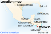
Nicaragua
is bound on the north by Honduras, on the east by the Caribbean
Sea, on the south by Costa Rica, and on the west by the Pacific
Ocean. It's a little bit bigger than the US state of New York with
an area of 130,000 square kilometers. The capital city, Managua,
is by far the largest, most developed, and hottest city in Nicaragua.
About a million people live in Managua
Nicaraguan
highlands, with an average elevation of about 610m, cross Nicaragua
from the northwest to the southeast. Several mountain ranges, the
highest of which, the Cordillera Isabelia, reaches an elevation
of more than 2,100m, cut the highlands from east to west. There's
a great big basin in the west which contains two lakes, Lake Nicaragua,
the largest in Central America, and Lake Managua which are connected
by the Tipitapa River. A chain of volcanoes, part of the ring-of-fire,
rise up between the lakes and Pacific coast. In the east, the Caribbean
coastal plain know as the Costa de Mosquitoes (Mosquito Coast) extends
some 72km inland and is partly overgrown with rain forest. The four
principal rivers, the San Juan (Saint John), Coco (Coconut), Grande
(Big), and Escondido (Hidden), empty into the Caribbean.
The
coastal regions of Nicaragua have a tropical climate with an average
temperature of 25.5C and 26.5C. In the higher altitudes in the interior
the temperature varies between 15.5C and 26.5C. The rainy season
is from May to October .
Nicaragua
is lucky to have some of the best and most abundant resources in
Central America. It's volcanic soil is perfect for growing rich
crops, the volcanoes provide geothermal energy potential, and Nicaragua
also has some petroleum and mineral reserves. Nicaragua also has
rich forests
Nicaragua
in few words
Official language: Spanish
People per square kilometer: 36.7
Climate: tropical in lowlands, cooler in highlands
Border countries: Costa Rica 309 km, Honduras 922 km
Natural resources: gold, silver, copper, tungsten, lead,
zinc, timber, fish
Population: 4,812,569 (July 2000 est.)
Government type: republic
Capital: Managua
Administrative
divisions: 15 departments (departamentos, singular - departamento),
2 autonomous regions (regiones autónomas, singular - region
autónoma); Boaco, Carazo, Chinandega, Chontales, Esteli,
Granada, Jinotega, Leon, Madriz, Managua, Masaya, Matagalpa, Nueva
Segovia, Rio San Juan, Rivas, Atlantico Norte, Atlantico Sur
Up
|